
Led by the Rhode Island (RI) Coastal Resources Management Council and the Town of Charlestown, the Ninigret Pond Salt Marsh Restoration and Enhancement Project included a team of local stakeholders and state and federal partners. After a series of planning meetings, ecological and social goals (Raposa et al. 2022) set by the multi-partner team were to:


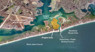
The geographic scope was set as the Ninigret Pond back-barrier salt marsh (Figure 2) adjacent to a fabricated breachway in Charlestown, RI, based on a combination of management objectives for the area and the co-located availability of a dredged material source, as well as an opportunity to combine ecological restoration goals with defined social goals of the local community.
The project incorporated a Climate Change Adaptation Strategy (Wigand et al. 2017), which included specific monitoring objectives to quantify ecological effects of dredged sediment placement (i.e., beneficial re-use of dredged materials) on a "drowning" marsh by measuring key physical and biological parameters before and after sediment placement and at a nearby control marsh.

The planning team documented threats to the Ninigret Pond marsh system based on evidence of prolonged flooding, inundation stress (large areas of marsh platform die-off; Figure 3), and marsh edge erosion resulting from accelerated sea level rise (SLR).
 due to inundation stress." width="960" height="603" />
The planning team used the outputs of Sea Level Affecting Marshes Model scenarios (Figure 4), die-off areas, and total unvegetated cover to assess marsh vulnerability to SLR.


A specific identified site, the Ninigret marsh (Figure 5), was the selected focus of the project based on evaluation of the site's degraded marsh condition (see Step 2), vulnerability to sea level rise, and concern over high marsh loss (Watson et al. 2017) in the broader region. Other prioritization factors for this particular site included location adjacent to a previously permitted dredge area that could serve as a sediment source to test a relatively new climate adaptation methodology (sediment placement to build elevation capital) and project team knowledge of the community’s goal to maintain the previously dredged basin for recreation and navigation.
Targeted dredged sediment placement on degraded marsh (a marsh elevation enhancement technique; Figure 6), followed by restoration of wetland grasses through plantings (Figure 7), were identified and selected as the intervention tactics that would build resiliency to sea level rise (SLR) and fulfill both the ecological and community goals identified in Step 1. Restoration goals and construction/dredging considerations drove project design.


The volume of dredged sediment to place on the existing marsh platform in the project area (Figure 8) was designed to achieve maximum elevation capital while not exceeding target elevation ranges that support the growth of dominant, native high marsh plant species. Selecting the upper ranges of native plant species growth elevations as elevation targets achieved this criterion, thereby reducing future elevation maintenance costs and extending the expected life span of the restoration project. The volume of material needed to achieve target elevations was estimated based on the differences between existing and target platform elevations in degraded subareas of the marsh.


The core planning partners reviewed the proposed project, which represents the assembled outputs from steps one through four (i.e., goals & objectives, vulnerabilities, management targets, monitoring design) and developed the components into an action plan for implementation.
Through this plan integration, roles were defined for project partners: Coastal Resources Management Council as project lead and funding applicant; Save The Bay (non-governmental organization; NGO) as the lead for maintenance and plantings; Save the Bay, Rhode Island National Estuarine Research Reserve, and U.S. Environmental Protection Agency for monitoring; the Town as the state and federal permit applicant; and the Salt Ponds Coalition (local watershed NGO) leading community outreach and support.
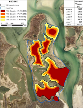

The project team developed a detailed conceptual plan in coordination with the engineering consultant through several team meetings. The primary design consideration was defining the needed volume of dredged material as a balance between fulfilling the social goal of maintaining the basin for recreation with the ecological goal of restoring marsh elevation (Figure 9) and building the resilience of the marsh system.

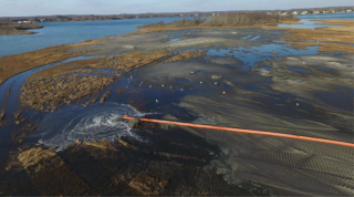
For implementation of the dredged sediment placement intervention (Figure 10), the Coastal Resources Management Council led construction oversight and reported information about project schedule and progress to the planning team as construction proceeded. Implementation progress was also monitored by knowledgeable stakeholders (town representatives).
Following the sediment placement, the marsh planting phase (Figure 11) was primarily carried out by volunteers coordinated by the non-governmental organization project partner (Save the Bay), during which corrections were made to site grades and drainage.

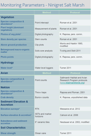
The project planning team developed a comprehensive monitoring plan to evaluate effectiveness of the sediment placement technique, as reflected in hydrological, geophysical, and biological responses. Parameters monitored included inundation patterns, elevation, salinity, soils, vegetation, nekton, and birds (Figure 12). A BACI (Before/After/Control/Impact) design was established, using a control site at a nearby National Wildlife Refuge, so that monitoring would be done before and after project implementation at both the control and impact (i.e., restoration) sites.
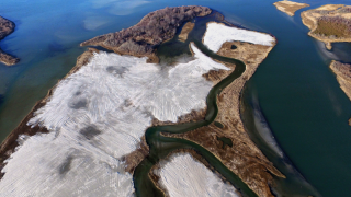
Project implementation included placement of 26,000 cubic meters of dredged material (Figure 13) and the restoration of ~20 acres of marsh, at a total cost of about $1.6 million (for design, engineering, permitting, and construction/ dredging). Note, however, that there was no formal monitoring of social indicators for this project. Due to the lead project team members' limited capacity, inclusion of stakeholders and partners in planning (steps 1-4) and implementation (steps 5, 6) was essential to enabling projects of greater scope and scale.
Documentation of pre- and post-sediment placement monitoring data, compared between the restoration site and a control site, enabled project progress and success evaluation .
Key findings (Figure 14):
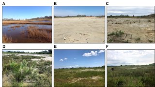

Monitoring results not only informed the evaluation of project success and potential adaptative management activities needed, but also provided lessons learned that can be applied to future marsh restoration/adaptation interventions using dredged sediment placement. Examples include improved information on:
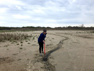
Adaptive management activities (Figure 15) during approximately two years following sediment placement were informed by marsh-scale salinity mapping that identified areas of high salinity and where freshwater inputs were located and included adjustments to elevations and marsh hydrology (e.g., excavation of runnels) to drain surface water and discourage colonization of invasive Phragmites australis, as well as additional planting of native marsh plants and continued treatment and removal of Phragmites.